|
Hazard Maps
(a class assignment, not for real use)
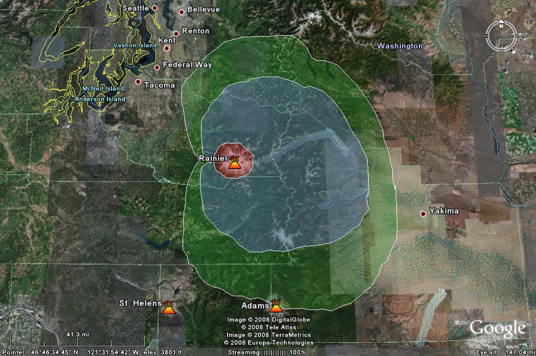
A Tephra Hazard
Map of Mt. Rainier
Red-- (meters thick)
Extremely dangerous and should be completely evacuated
Blue-- (1-5cm thick)
Highly dangerous, little to no visibility, danger to
structures
Green-- (.5-1cm thick)
Dangerous, poor visibility, extensive damage to crops
There are three
zones of danger in terms of fall out from an explosion
of Mt. Rainier. The Tephra would generally favor the
east because of the dominating winds. The range of fall
is quite small for a volcano like Mt. Rainier,
especially when compared to the range of fall out from
Mt. St. Helens. However, any sort of eruption column and
fall out can severely damage aircrafts and therefore
there needs to be a wide no fly zone.
The red zone is the
most dangerous with large falling ballistics that could
be as large as 10s of centimeters across and create a
layer several meters thick. These hot pieces of Tephra
could start fires and would cause death or serious
injury on impact. This would be an area that would be
extremely dangerous to be in during an eruption, not
only from the fall out but also from the many other
hazards such as Pyroclastic flows and Lahars.
The blue zone is
still highly dangerous and would considerably disrupt
life within it. However, unlike the red zone, the tephra
would be resembling fine ash rather than larger pieces
of pumice. This can be even more dangerous as it is
capable of completely blocking out light and reducing
visibility to a few centimeters. This can cause
devastation to structures as even a layer of 5cm could
collapse a roof, public water and sewage systems could
be overwhelmed by the fine material and fail, and
people's respiratory systems can be at risk.
The green
zone is capable of getting .5-1cm of ash. There is still
poor visibility for these areas, and therefore
impossible to safely drive in. The public water and
sewer system can still fail from the inability to
process such fine ash. But the largest and most
long-term issue is the damage to crops from fall out.
Even a small layer of ash can wreck a crop for a season.
The clean up required will similarly take up time and
resources for weeks after the eruption.
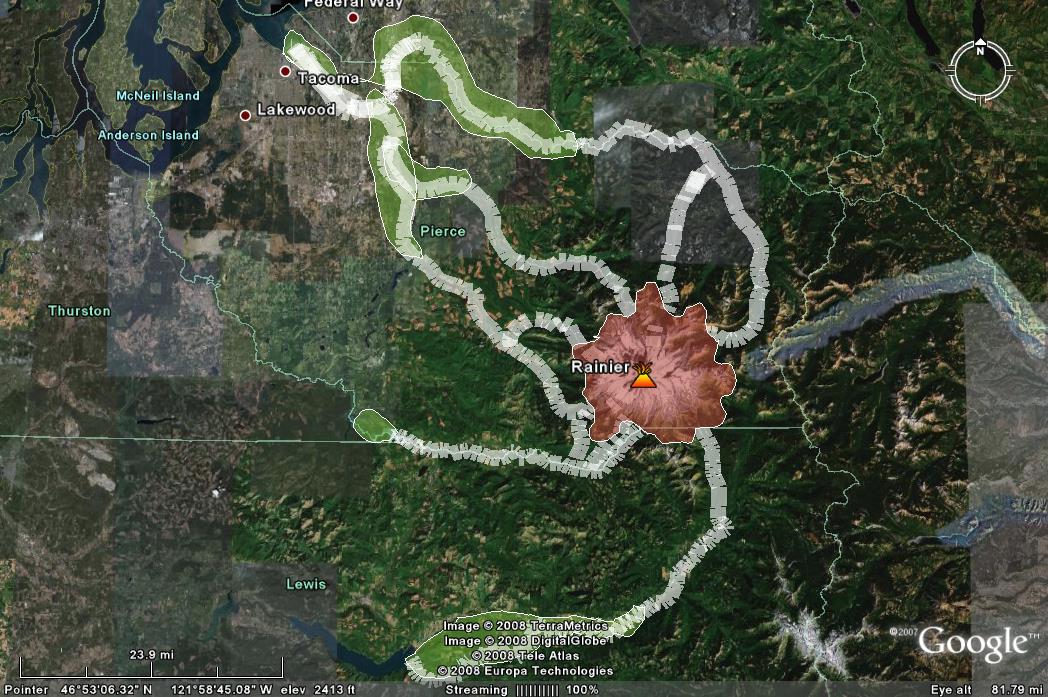
Lahars and Pyroclastic
Flows Hazard Map
Red--Highly Dangerous
area prone to Pyroclastic Flows, Surges and Lahars
White--Possible primary
or secondary Lahar flows
Green--Possible Flood
areas caused by Lahars
The most dangerous hazard
that Mt. Rainier can produce is a Lahar: fast moving
(10-60 km/hr) debris and mud ( most commonly created by
melted snow and ash at Mt. Rainier) flow. It is capable
of carrying boulders the size of buses hundreds of
kilometers from the vent. The consistency is similar to
cement and tends to be devastating to wherever it
travels . The largest Lahar in the world's history was
produced by this volcano on top of which many towns are
now built . The Osceola Mudflow occurred 5,600 years ago
and covered an area of 550 km squared reaching the
southern Seattle suburb of Kent and the current Port of
Tacoma
XII. Secondary Lahars can also be triggered
months after an eruption. If enough ash has accumulated
on top of a ridge, and there is a large amount of
rainfall, this can create a Lahar that will travel down
channels and rivers collecting more debris as it goes.
Similarly, if Mt Rainier emits hot gas or the volcano
starts to warm up, then the snow and glaciers on top can
melt and create a Lahar. Secondary Lahars are often more
dangerous than primary ones as many people can be
unprepared since there is no eruption to force people to
get ready.
The Red area
is highly dangerous and should be off limits to
everyone. This is an area prone to Pyroclastic Flows
which are extremely hot (570 degrees Fahrenheit) and are
very fast (200miles/hr). Due to their temperature, they
can melt the snow and glaciers and turn the Pyroclastic
flows into Lahars. This entire vicinity will prone to
all sorts of volcanic hazards in which no one would be
safe.
The White
areas are possible paths that primary and secondary
Lahars could take. They all follow deep river valleys
which would cause the Lahras to pick up even more water.
In this map I have created the worst case scenario. Only
if Mt Rainier has an large Plinian eruption with a VEI
of 5 or 6 will these Lahars probably be able to reach
the port of Tacoma, many will settle further upstream.
The Green is
possible flood areas that these Lahars could create. Not
only do the Lahars themselves contain a lot of water,
but they can break damns and block rivers. The low lying
flat areas in and near Tacoma and its surrounding cities
would be prime examples of where water may collect.
Further up the Lahar paths, however, the valley walls
are too steep and therefore most likely any flooding
would be contained and not be too devastating. It is
only close to farm lands and bodies of water that floods
would be a large hazard due tot he leveling out of
topography.
|